


Ask About This Course
| Exam Body | Internal Diploma Malaysia |
|---|---|
| Course Duration | 3 Yrs |
| Part Time/Full Time | Full Time |
| Fees | 32380/Course |
| Faculty | Diploma Programme (Built Environment and Surveying) |
| Conducted entirely in Malaysia | Yes |
| Awarding Country | Malaysia |
| Level of Study | Diploma Level |
| Field of Study | Architecture & Building |
| Course Description | Graduate of Diploma in Land Survey, will achieve the followings objectives:
|
| Curriculum | Curriculum Structure Year 1 TITAS, Malaysia Dynamic, Foundation Engineering Mathematics, English Proficiency, Physics, Basic Surveying, Introduction To Geomatic, English For Academic Study, Engineering Mathematics, Geodesy, Cartography, Engineering Surveying, Field Astronomy, Computer Aided Design For Surveyors, Co Curriculum. Year 2 English For Professional Communication, Creative and Critical Thinking, Higher Engineering Mathematics, Engineering Survey Technology, Computer Programming, Introduction To Geographical Information System, Islamic Institutions, Cadastral Surveying, Survey Adjustment, GPS Survey, Introduction To Remote Sensing, Introduction To Utility Mapping. Year 3 Islamic Worldview/Self Development, Entrepreneurship and Enterprise Development, Cadastral Practice, Photogrammetry, Hydrographic Surveying, Land Administration, Survey Camp, Industrial Training, Industrial Training Report. |
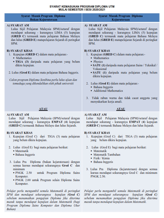
| Entry Requirements | Please refer - http://space.utm.my/wp-content/uploads/2020/02/SYARAT-KEMASUKAN-PROGRAM-DIPLOMA-UTM-SESI-20192020_001.jpg |
| Intake Months | May and June |
| Career Prospects | Graduates of the program can work as:
Diploma holders in Land Surveying can work as a technical assistant and may also continue for degree and professional courses to qualify as a Licensed Land Surveyor. |
All fees are in RM (Ringgit Malaysia) currency unless stated otherwise.
Other Courses in this Level of Study Other Courses in this Field of Study


